
Winds at the top of the troposphere are generally pole ward and westerly in direction. Figure 7q-1 describes these upper air westerlies along with some other associated weather features. Three zones of westerlies can be seen in each hemisphere on this illustration. Each zone is associated with either the Hadley, Ferrel, or Polar circulation cell.
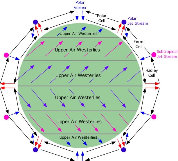
Figure 7q-1: Simplified global three-cell upper air circulation patterns.
The polar jet stream is formed by the deflection of upper air winds by coriolis acceleration (see Figure 7q-3 below). It resembles a stream of water moving west to east and has an altitude of about 10 kilometers. Its air flow is intensified by the strong temperature and pressure gradient that develops when cold air from the poles meets warm air from the tropics. Wind velocity is highest in the core of the polar jet stream where speeds can be as high as 300 kilometers per hour. The jet stream core is surrounded by slower moving air that has an average velocity of 130 kilometers per hour in winter and 65 kilometers per hour in summer.
Associated with the polar jet stream is the polar front. The polar front represents the zone where warm air from the subtropics (pink) and cold air (blue) from the poles meet (see Figure 7q-3 below). At this zone, massive exchanges of energy occur in the form of storms known as the mid-latitude cyclones. The shape and position of waves in the polar jet stream determine the location and the intensity of the mid-latitude cyclones. In general, mid-latitude cyclones form beneath polar jet stream troughs. The following satellite image (Figure 7q-2), taken from above the South Pole, shows a number of mid-latitude cyclones circling Antarctica. Each mid-latidude cyclone wave is defined by the cloud development associated with frontal uplift.
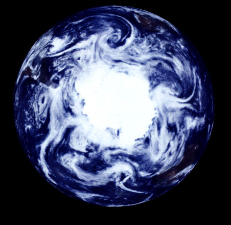
Figure 7q-2: Satellite view of the atmospheric circulation at the South Pole. (Source: NASA).
The subtropical jet stream is located approximately 13 kilometers above the subtropical high pressure zone. The reason for its formation is similar to the polar jet stream. However, the subtropical jet stream is weaker. Its slower wind speeds are the result of a weaker latitudinal temperature and pressure gradient.
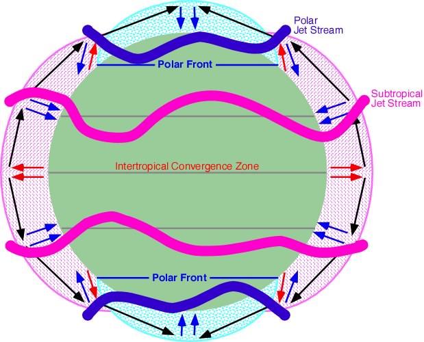 |
| Figure 7q-3: Polar and subtropical jet streams. |
Pidwirny, M. (2006). "Upper Air Winds and the Jet Streams". Fundamentals of Physical Geography, 2nd Edition. 5/1/2012. http://www.physicalgeography.net/fundamentals/7q.html
Do you like this post? Please link back to this article by copying one of the codes below.
URL: HTML link code: BB (forum) link code: