
Mid-latitude or frontal cyclones are large traveling atmospheric cyclonic storms up to 2000 kilometers in diameter with centers of low atmospheric pressure. An intense mid-latitude cyclone may have a surface pressure as low as 970 millibars, compared to an average sea-level pressure of 1013 millibars. Normally, individual frontal cyclones exist for about 3 to 10 days moving in a generally west to east direction. Frontal cyclones are the dominant weather event of the Earth's mid-latitudes forming along the polar front. (Figure 7s-1).
Figure 7s-1: A series of mid-latitude cyclones forming along the polar front (black line with red half circle and blue triangle symbols). On the illustration, the low pressure center of the mid-latitude cyclones is identfied by a red L. The systems located along the west and east coast of North America are in the middle stage of their life. The mid-latitude cyclone east of Greenland is at the end of its life cycle. In their mature stage, mid-latitude cyclones have a warm front on the east side of the storm's center and a cold front to the west. The cold front travels faster than the warm front. Near the end of the storm's life the cold front catches up to the warm front causing a condition known as occlusion.
Mid-latitude cyclones are the result of the dynamic interaction of warm tropical and cold polar air masses at the polar front. This interaction causes the warm air to be cyclonically lifted vertically into the atmosphere where it combines with colder upper atmosphere air. This process also helps to transport excess energy from the lower latitudes to the higher latitudes.
The mid-latitude cyclone is rarely motionless and commonly travels about 1200 kilometers in one day. Its direction of movement is generally eastward (Figure 7s-2). Precise movement of this weather system is controlled by the orientation of the polar jet stream in the upper troposphere. An estimate of future movement of the mid-latitude cyclone can be determined by the winds directly behind the cold front. If the winds are 70 kilometers per hour, the cyclone can be projected to continue its movement along the ground surface at this velocity.
Figure 7s-2: Typical paths of mid-latitude cyclones are represented by black arrows. This image also shows the typical paths traveled by subtropical hurricanes (green arrows).
Figure 7s-3 describes the patterns of wind flow, surface pressure, fronts, and zones of precipitation associated with a mid-latitude cyclone in the Northern Hemisphere. Around the low, winds blow counterclockwise and inwards (clockwise and inward in the Southern Hemisphere). West of the low, cold air traveling from the north and northwest creates a cold front extending from the cyclone's center to the southwest. Southeast of the low, northward moving warm air from the subtropics produces a warm front. Precipitation is located at the center of the low and along the fronts where air is being uplifted.
Mid-latitude cyclones can produce a wide variety of precipitation types. Precipitation types include: rain, freezing rain, hail, sleet, snow pellets, and snow. Frozen forms of precipitation (except hail) are common with storms that occur in the winter months. Hail is associated with severe thunderstorms that form along or in front of cold fronts during spring and summer months.

Figure 7s-3: Fronts, winds patterns, pressure patterns, and precipitation distribution found in an idealized mature mid-latitude cyclone.
|
Figure 7s-4 describes a vertical cross-section through a mature mid-latitude cyclone. In this cross-section, we can see how air temperature changes as we move from behind the cold front to a position ahead of the warm front. Behind the surface position of the cold front, forward moving cold dense air causes the uplift of the warm lighter air in advance of the front. Because this uplift is relatively rapid along a steep frontal gradient, the condensed water vapor quickly organizes itself into cumulus and then cumulonimbus clouds. Cumulonimbus clouds produce heavy precipitation and can develop into severe thunderstorms if conditions are right. Along the gently sloping warm front, the lifting of moist air produces first nimbostratus clouds followed by altostratus and cirrostratus. Precipitation is less intense along this front, varying from moderate to light showers some distance ahead of the surface location of the warm front.
Figure 7s-4: Vertical cross-section of the line A-B in Figure 7s-3.
Frontal cyclone development is related to polar jet stream processes. Within the jet stream, localized areas of air outflow can occur because of upper air divergence. Outflow results in the development of an upper air vacuum. To compensate for the vacuum in the upper atmosphere, surface air flows cyclonically upward into the outflow to replenish lost mass. The process stops and the mid-latitude cyclone dissipates when the upper air vacuum is filled with surface air.
Mid-latitude cyclones cause far less damage than tropical cyclones or hurricanes. Hurricanes involve much greater amounts of atmospheric energy exchange. As one goes away from the equator, the energy available to fuel a weather system decreases as the amount of solar radiation and heat declines. Mid-latitude cyclones can have winds as strong as what is associated with a weak hurricane. But, this is a rare occurrence. Frontal cyclones tend to be most disruptive to human activity during winter months. Winter storms can produce heavy snowfalls or freezing rain which slows down transportation, snaps powerlines, and kills vegetation. In January 1998, a winter storm in eastern North America resulted in more than 20 human deaths, billions of dollars of damage, the loss of electrical power in some areas for up to two weeks, and the destruction of many deciduous trees because of the weight of ice (Figures 7s-5, 7s-6, and 7s-7).
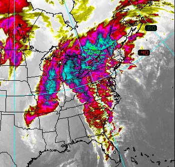
Figure 7s-5: GOES false color satellite image of the ice storm of January 1998. In the image, the center of the mid-latitude cyclone is located over the Great Lakes. This system pulled moisture from the Gulf of Mexico and the Atlantic Ocean which was converted into freezing rain and snow that fell from north-eastern United States to south-eastern Canada.
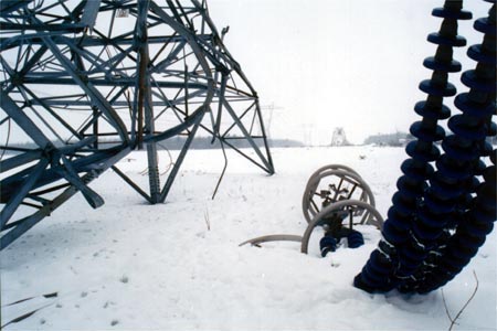
Figure 7s-6: The weight of ice collapsed many power-transmission towers leaving some areas without electricity for almost two weeks. (Source: Human Resources Development Canada - Ice Storm '98 Emergency: A Study in Response).
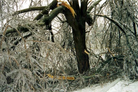
Figure 7s-7: Freezing rain from the 1998 ice storm also took its toll on many trees. (Source: Human Resources Development Canada - Ice Storm '98 Emergency: A Study in Response).
Cyclogenesis
The animation in Figure 7s-8 illustrates the life cycle or cyclogenesis of the mid-latitude cyclone. The cyclone begins as a weak disturbance somewhere along the frontal zone (stationary front) where cold air from polar regions meets warm air from the south (Stage 1). The collision of these two air masses results in the uplift of the warm air into the upper atmosphere creating a cyclonic spin around a low pressure center (Stages 2 and 3). During the middle stages of cyclogenesis, the storm intensifies and the pressure at the storm's center drops (Stages 4 and 5). The warm air south of the low's center and between the two fronts is known as the warm sector. Cold fronts usually move along the Earth's surface at velocities greater than the warm front. As a result, the late stages of cyclogenesis occur when the cold front overtakes the warm front causing the air in the warm sector to be lifted into the upper atmosphere (Stages 6 and 7). The resulting boundary between the cold and cool air masses is called an occluded front. A day or two after occlusion the occluded front dissipates, winds subside, and a stationary front forms on the surface of the Earth again (Stages 8 to 10).
CITATION
Pidwirny, M. (2006). "The Mid-Latitude Cyclone". Fundamentals of Physical Geography, 2nd Edition. 6/1/2012. http://www.physicalgeography.net/fundamentals/7s.html
Do you like this post? Please link back to this article by copying one of the codes below.
URL: HTML link code: BB (forum) link code: