
(a) CRUSTAL DEFORMATION PROCESSES

(b) EARTH QUAKES
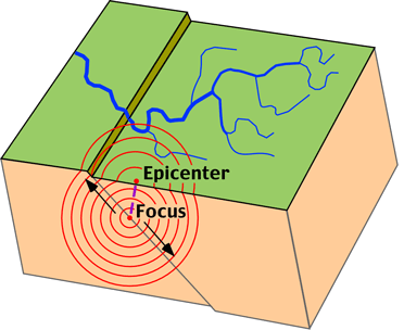
Earthquake Waves Earthquakes are a form of wave energy that is transferred through bedrock. Motion is transmitted from the point of sudden energy release, the earthquake focus, as spherical seismic waves that travel in all directions outward (Figure 10m-3). The point on the Earth's surface directly above the focus is termed the epicenter.
The topographic map illustrated in Figure 10l-1 suggests that the Earth's surface has been deformed. This deformation is the result of forces that are strong enough to move ocean sediments to an eleveation many thousands meters above sea level. In previous lectures, we have discovered that this displacement of rock can be caused by tectonic plate movement and subduction, volcanic activity, and intrusive igneous activity.
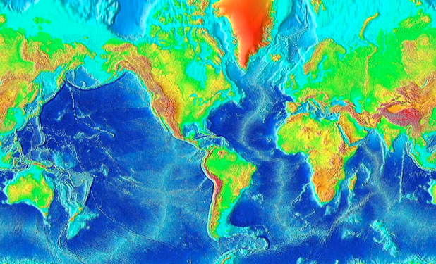
Figure 10l-1: Topographic relief of the Earth's terrestrial surface and ocean basins. Ocean trenches and the ocean floor have the lowest elevations on the image and are colored dark blue. Elevation is indicated by color. The legend below shows the relationship between color and elevation. (Source: National Geophysical Data Center, National Oceanic and Atmospheric Administration).
Deformation of rock involves changes in the shape and/or volume of these substances. Changes in shape and volume occur when stress and strain causes rock to buckle and fracture or crumple into folds. A fold can be defined as a bend in rock that is the response to compressional forces. Folds are most visible in rocks that contain layering. For plastic deformation of rock to occur a number of conditions must be met, including:
- The rock material must have the ability to deform under pressure and heat.
- The higher the temperature of the rock the more plastic it becomes.
- Pressure must not exceed the internal strength of the rock. If it does, fracturing occurs.
- Deformation must be applied slowly.
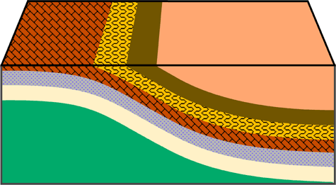
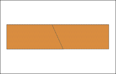
A number of different folds have been recognized and classified by geologists. The simplest type of fold is called a monocline (Figure 10i-2). This fold involves a slight bend in otherwise parallel layers of rock.
Figure 10l-2: Monocline fold.
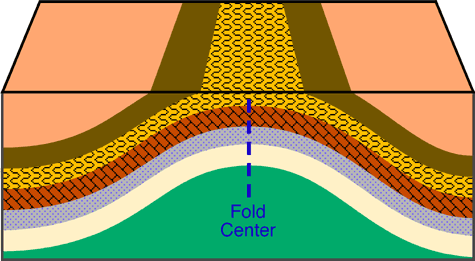
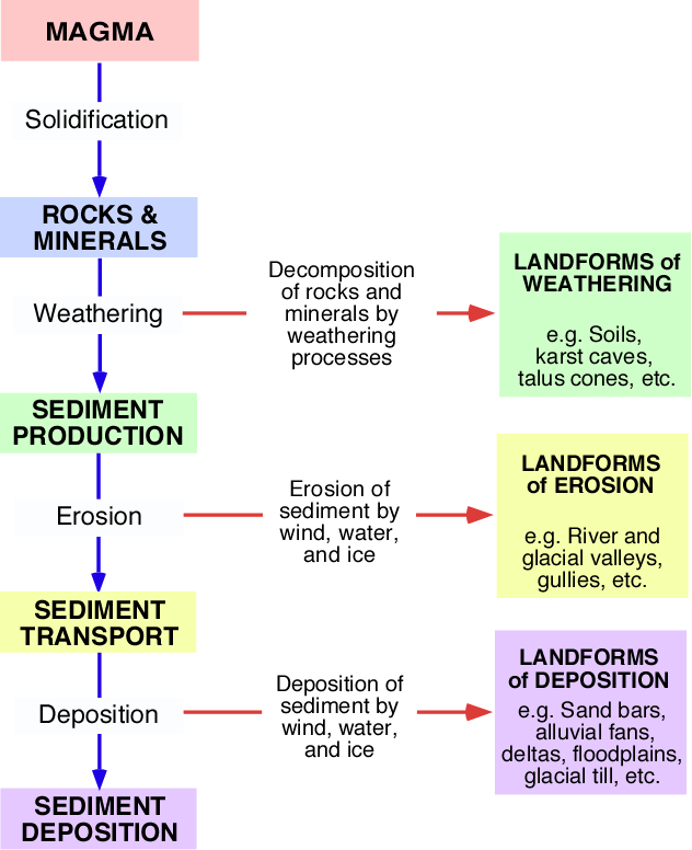
An anticline is a convex up fold in rock that resembles an arch like structure with the rock beds (or limbs) dipping way from the center of the structure (Figure 10l-3).
Figure 10l-3: Anticline fold. Note how the rock layers dip away from the center of the fold are roughly symmetrical.
A syncline is a fold where the rock layers are warped downward (Figure 10l-4 and 10l-5). Both anticlines and synclines are the result of compressional stress.
 | |
Figure 10l-4: Syncline fold. Note how the rock layers dip toward the center of the fold and are roughly symmetrical.
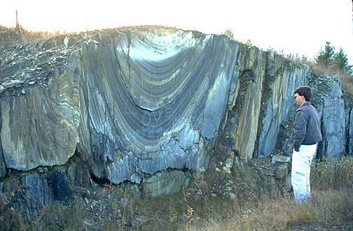
Figure 10l-5: Synclinal folds in bedrock, near Saint-Godard-de-Lejeune, Canada. (Source: Natural Resources Canada - Terrain Sciences Division - Canadian Landscapes).
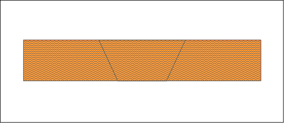
More complex fold types can develop in situations where lateral pressures become greater. The greater pressure results in anticlines andsynclines that are inclined and asymmetrical (Figure 10l-6).
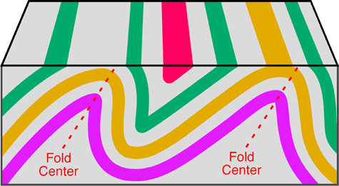
Figure 10l-6: The following illustration shows two anticline folds which are inclined. Also note how the beds on either side of the fold center are asymmetrical.
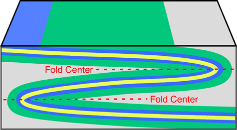
A recumbent fold develops if the center of the fold moves from being once vertical to a horizontal position (Figure 10l-7). Recumbent folds are commonly found in the core of mountain ranges and indicate that compression and/or shear forces were stronger in one direction. Extreme stress and pressure can sometimes cause the rocks to shear along a plane of weakness creating a fault. We call the combination of a fault and a fold in a rock an overthrust fault.
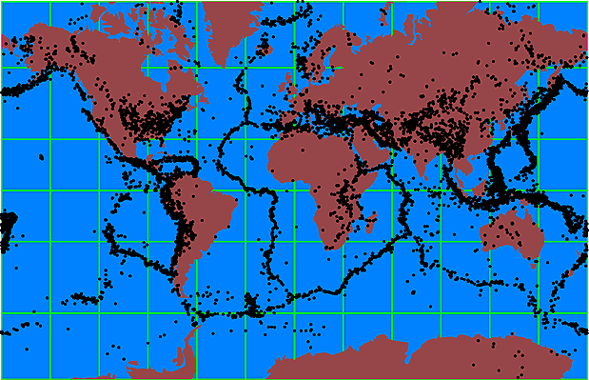
Faults form in rocks when the stresses overcome the internal strength of the rock resulting in a fracture. A fault can be defined as the displacement of once connected blocks of rock along a fault plane. This can occur in any direction with the blocks moving away from each other. Faults occur from both tensional and compressional forces. Figure 10l-8 shows the location of some of the major faults located on the Earth.
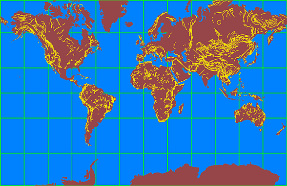
Figure 10l-8: Location of some of the major faults on the Earth. Note that many of these faults are in mountainous regions.
There are several different kinds of faults. These faults are named according to the type of stress that acts on the rock and by the nature of the movement of the rock blocks either side of the fault plane. Normal faults occur when tensional forces act in opposite directions and cause one slab of the rock to be displaced up and the other slab down (Figure 10l-9).
Reverse faults develop when compressional forces exist (Figure 10l-10). Compression causes one block to be pushed up and over the other block.
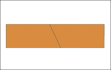 Figure 10l-10: Animation of a reverse fault.
A graben fault is produced when tensional stresses result in the subsidence of a block of rock. On a large scale these features are known as Rift Valleys (Figure 10l-11).
 |
A horst fault is the development of two reverse faults causing a block of rock to be pushed up (Figure 10l-12).
Figure 10l-12: Animation of a horst fault.
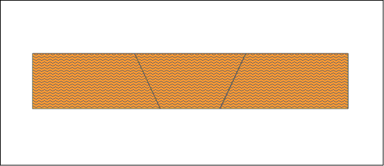
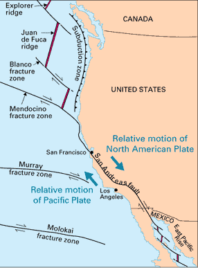
The final major type of fault is the strike-slip or transform fault. These faults are vertical in nature and are produced where the stresses are exerted parallel to each other (Figure 10l-13). A well-known example of this type of fault is the San Andreas fault in California.
Figure 10l-13: Transcurrent fault zones on and off the West coast of North America. (Source: U.S. Geological Survey).
(b) EARTH QUAKES
An earthquake is a sudden vibration or trembling in the Earth. More than 150,000 tremors strong enough to be felt by humans occur each year worldwide. Earthquake motion is caused by the quick release of stored potential energy into the kinetic energy of motion. Most earthquakes are produced along faults, tectonic plate boundary zones, or along the mid-oceanic ridges (Figures 10m-1 and 10m-2). At these areas, large masses of rock that are moving past each other can become locked due to friction. Friction is overcome when the accumulating stress has enough force to cause a sudden slippage of the rock masses.
The magnitude of the shock wave released into the surrounding rocks is controlled by the quantity of stress built up because of friction, the distance the rock moved when the slippage occurred, and ability of the rock to transmit the energy contained in the seismic waves. The San Francisco earthquake of 1906 involved a 6 meter horizontal displacement of bedrock. Sometime after the main shock wave, aftershocks can occur because of the continued release of frictional stress. Most aftershocks are smaller than the main earthquake, but they can still cause considerable damage to already weakened natural and human constructed features.
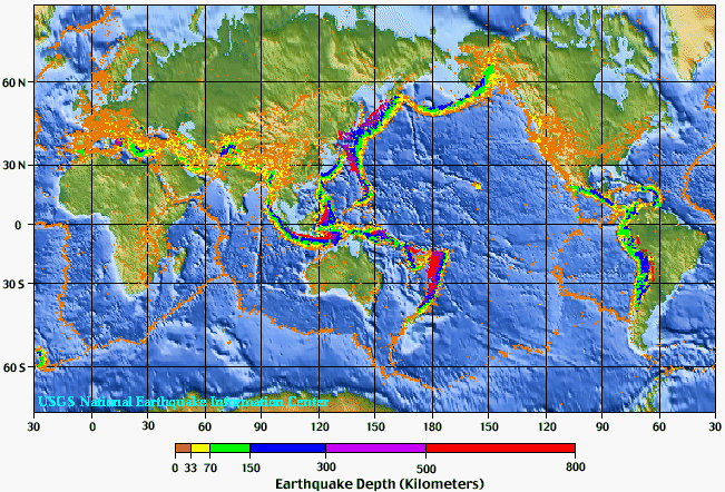
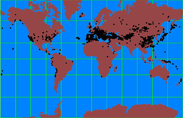
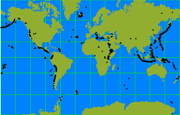
Figure 10m-1: Distribution of earthquake epicenters from 1975 to 1995. Depth of the earthquake focus is indicated by color. Deep earthquakes occur in areas where oceanic crust is being actively subducted. About 90% of all earthquakes occur at a depth between 0 and 100 kilometers. (Source: U.S. Geologic Survey,National Earthquake Information Center).
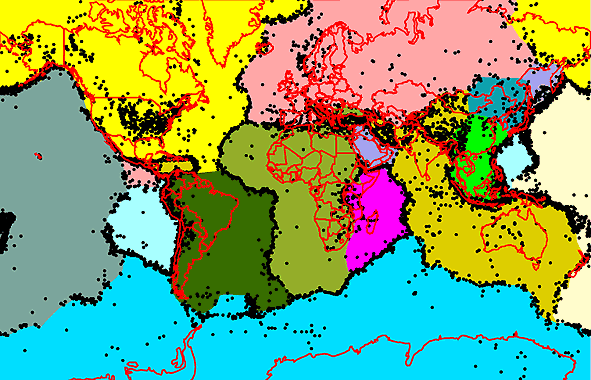 |
Figure 10m-2: Distribution of earthquakes with a magnitude less than 5.0 relative to the various tectonic plates found on the Earth's surface. Each tectonic plate has been given a unique color. This illustration indicates that the majority of small earthquakes occur along plate boundaries.
Figure 10m-3: Movement of body waves away from the focus of the earthquake. The epicenter is the location on the surface directly above the earthquake's focus.
Two different types of seismic waves have been described by geologists: body waves and surface waves. Body waves are seismic waves that travel through the lithosphere. Two kinds of body waves exist: P-waves and S-waves. Both of these waves produce a sharp jolt or shaking. P-waves or primary waves are formed by the alternate expansion and contraction of bedrock and cause the volume of the material they travel through to change.
They travel at a speed of about 5 to 7 kilometers per second through the lithosphere and about 8 kilometers per second in the asthenosphere. The speed of sound is about 0.30 kilometers per second. P-waves also have the ability to travel through solid, liquid, and gaseous materials. When some P-waves move from the ground to the lower atmosphere, the sound wave that is produced can sometimes be heard by humans and animals.
They travel at a speed of about 5 to 7 kilometers per second through the lithosphere and about 8 kilometers per second in the asthenosphere. The speed of sound is about 0.30 kilometers per second. P-waves also have the ability to travel through solid, liquid, and gaseous materials. When some P-waves move from the ground to the lower atmosphere, the sound wave that is produced can sometimes be heard by humans and animals.
S-waves or secondary waves are a second type of body wave. These waves are slower than P-waves and can only move through solid materials. S-waves are produced by shear stresses and move the materials they pass through in a perpendicular (up and down or side to side) direction.
Surface waves travel at or near the Earth's surface. These waves produce a rolling or swaying motion causing the Earth's surface to behave like waves on the ocean. The velocity of these waves is slower than body waves. Despite their slow speed, these waves are particularly destructive to human construction because they cause considerable ground movement.
Earthquake Measurement
The strength of an earthquake can be measured by a device called a seismograph. When an earthquake occurs this device converts the wave energy into a standard unit of measurement like the Richter scale. In the Richter scale, units of measurement are referred to as magnitudes. The Richter scale is logarithmic. Thus, each unit increase in magnitude represents 10 times more energy released. Table 10m-1 describes the relationship between Richter scale magnitude and energy released. The following equation can be used to approximate the amount of energy released from an earthquake in joules when Richter magnitude (M) is known:
Energy in joules = 1.74 x 10(5 + 1.44*M)
Table 10m-1: Relationship between Richter Scale magnitude and energy released.
Magnitude in
Richter Scale |
Energy Released
in Joules |
Comment
|
2.0
|
1.3 x 10⁸
| Smallest earthquake detectable by people. |
5.0
|
2.8 x 10¹²
| Energy released by the Hiroshima atomic bomb. |
6.0 - 6.9
|
7.6 x 10¹³ to 1.5 x 10¹⁵
| About 120 shallow earthquakes of this magnitude occur each year on the Earth. |
6.7
|
7.7 x 10¹⁴
| Northridge, California earthquake January 17, 1994. |
7.0
|
2.1 x 10¹⁵
| Major earthquake threshold. |
7.4
|
7.9 x 10¹⁵
| Turkey earthquake August 17, 1999. More than 12,000 people killed. |
7.6
|
1.5 x 10¹⁶
| Deadliest earthquake in the last 100 years. Tangshan, China, July 28, 1976. Approximately 255,000 people perished. |
8.3
|
1.6 x 10¹⁷
| San Francisco earthquake of April 18, 1906. |
9.3
|
4.3 x 10¹⁸
| December 26, 2004 Sumatra earthquake. |
9.5
|
8.3 x 10¹⁸
| Most powerful earthquake recorded in the last 100 years. Southern Chile on May 22, 1960. Claimed 3,000 lives. |
Figures 10m-4 and 10m-5 describe the spatial distribution of small and large earthquakes respectively. These maps indicate that large earthquakes have distributions that are quite different from small events. Many large earthquakes occur some distance away from a plate boundary. Some geologists believe that these powerful earthquakes may be occurring along ancient faults that are buried deep in the continental crust. Recent seismic studies in the central United States have discovered one such fault located thousands of meters below the lower Mississippi Valley. Some large earthquakes occur at particular locations along the plate boundaries. Scientists believe that these areas represent zones along adjacent plates that have greater frictional resistance and stress.
| Figure 10m-4: Distribution of earthquakes with a magnitude less than 5 on the Richter Scale. |
| Figure 10m-6: Distribution of earthquakes with a magnitude greater than 7 on the Richter Scale. |
Earthquake Damage and Destruction
Earthquakes are a considerable hazard to humans. Earthquakes can cause destruction by structurally damaging buildings and dwellings, fires,tsunamis, and mass wasting (see Figures 10m-7 to 10m-11). Earthquakes can also take human lives. The amount of damage and loss of life depends on a number of factors. Some of the more important factors are:
- Time of day. Higher losses of life tend to occur on weekdays between the hours of 9:00 AM to 4:00 PM. During this time interval many people are in large buildings because of work or school. Large structures are often less safe than smaller homes in an earthquake.
- Magnitude of the earthquake and duration of the event.
- Distance form the earthquake's focus. The strength of the shock waves diminish with distance from the focus.
- Geology of the area effected and soil type. Some rock types transmit seismic wave energy more readily. Buildings on solid bedrock tend to receive less damage. Unconsolidated rock and sediments have a tendency to increase the amplitude and duration of the seismic waves increasing the potential for damage. Some soil types when saturated become liquefied (Figure 10m-7).
- Type of building construction. Some building materials and designs are more susceptible to earthquake damage (Figure 10m-8).
- Population density. More people often means greater chance of injury and death.
The greatest loss of life because of an earthquake this century occurred in Tangshan, China in 1976 when an estimated 250,000 people died. In 1556, a large earthquake in the Shanxi Province of China was estimated to have caused the death of about 1,000,000 people.
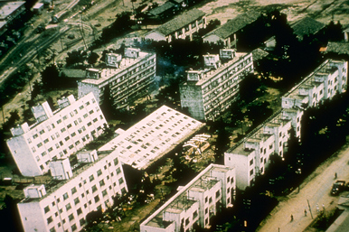
Figure 10m-6: Earthquake of June 16, 1964 in Niigata, Japan had a magnitude of 7.4. Liquefaction of some soils in the area caused large apartment buildings to tip over on their sides. (Source: Image provided by the National Geophysical Data Center, NOAA).
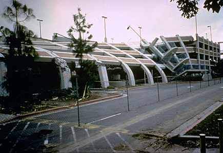 |
Figure 10m-7: A view of a parking lot on the campus of California State University. Columns of reinforced concrete failed after the 1994 Northridge earthquake and its aftershocks. (Source: Photography by M. Celebi, US Geological Survey. Image provided by the National Geophysical Data Center, NOAA).
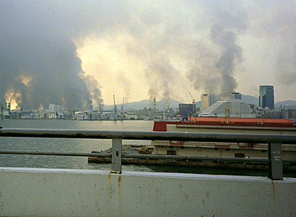
A common problem associated with earthquakes in urban areas is fire (Figure 10m-8). Shaking and ground displacement often causes the severing of electrical and gas lines leading to the development of many localized fires. Response to this problem is usually not effective because shock waves also rupture pipes carrying water. In the San Francisco earthquake of 1906, almost 90% of the damage to buildings was caused by fire.
Figure 10m-8: The following image looks at downtown Kobe, Japan at about noon on the day of the 1995 earthquake. Many areas of downtown Kobe were on fire and there was no water pressure to put out the flames. (Source: Photograph by Roger Hutchison. Image provided by the National Geophysical Data Center, NOAA).
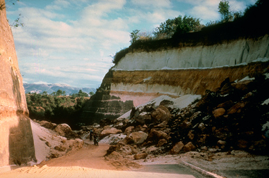
In mountainous regions, earthquake provoked landslides can cause many deaths and severe damage to built structures (Figure 10m-10). The town of Yungay, Peru was buried by a debris flow that was triggered by an earthquake that occurred on May 31, 1970. This disaster engulfed the town in seconds with mud, rock, ice, and water and took the lives of about 20,000 people.
Figure 10m-9: The Guatemala earthquake of February 4, 1976 had a magnitude of 7.5. This earthquake killed about 23,000 people, injured 76,000, and caused just over 1 billion dollars in property damage. The earthquake also caused a number of landslides. (Source: Photography by US Geological Survey. Image provided by the National Geophysical Data Center, NOAA).
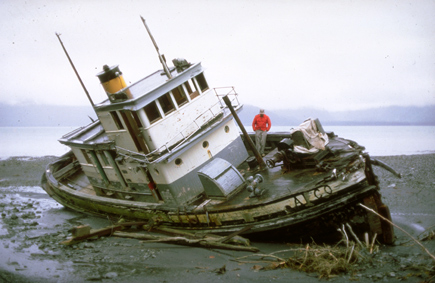
Another consequence of earthquakes is the generation of tsunamis (Figure 10m-10). Tsunamis, or tidal waves, form when an earthquake causes a sudden movement of the seafloor. This movement creates a wave in the water body which radiates outward in concentric shells. On the open ocean, these waves are usually no higher than one to three meters in height and travel at speed of about 750 kilometers per hour. Tsunamis become dangerous when they approach land. Frictional interaction of the waves with the ocean floor, as they near shore, causes the waves to slow down and collide into each other. This amalgamation of waves then produces a super wave that can be as tall as 65 meters in height.
Figure 10m-11: The earthquake of March 27, 1964, in the Gulf of Alaska generated a tsunami. This photo shows a beached fishing boat that was carried landward by the tsunami wave. (Source: Image provided by the National Geophysical Data Center, NOAA).
(c) VOLCANOES
A volcano is generally a conical shaped hill or mountain built by accumulations of lava flows, tephra, and volcanic ash. About 95% of active volcanoes occur at the plate subduction zones and at the mid-oceanic ridges (Figure 10n-1). The other 5% occur in areas associated with lithospheric hot spots. These hot spots have no direct relationships with areas of crustal creation or subduction zones. It is believed that hot spots are caused by plumes of rising magma that have their origin within the asthenosphere.
Figure 10n-1: Location of the Earth's major volcanoes. Most occur along tectonic plate boundaries where plate subduction creates rising plumes of magma. The volcanoes that do not occur along plate boundaries are the result of localized asthenosphere hot spots that melt through the Earth's crust. The Hawaiian Island chain of volcanoes was create by a hot spot.
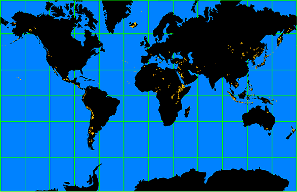
Over the last 2 million years, volcanoes have been depositing lava, tephra, and ash in particular areas of the globe (Figure 10n-2). These areas occur at hot spots, rift zones, and along plate boundaries where tectonic subduction is taking place.
Figure 10n-2: Location of major volcanic deposits laid down during the last 2 million years.
Not all volcanoes are the same. Geologists have classified five different types of volcanoes. This classification is based on the geomorphic form, magma chemistry, and the explosiveness of the eruption.
The least explosive type of volcano is called a basalt plateau. These volcanoes produce a very fluid basaltic magma with horizontal flows. The form of these volcanoes is flat to gently sloping and they can occupy an area from 100,000 to 1,000,000 square kilometers. Deposits of these volcanoes can be as thick as 1800 meters. Large basalt plateaus are found in the Columbia River Plateau, western India, northern Australia, Iceland, Brazil, Argentina, and Antarctica.
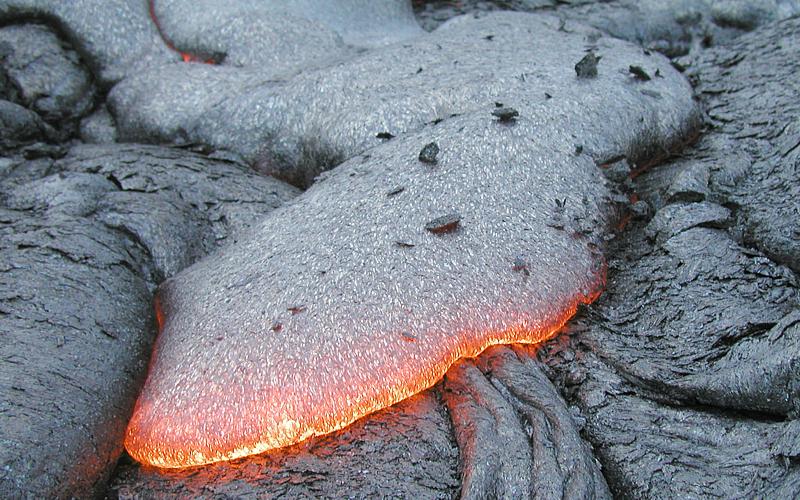
Some basaltic magmas can produce very large slightly sloping volcanoes, 6 to 12°, that have gently flowing magmas called shield volcanoes. Shield volcanoes can be up to 9000 meters tall. The volcanoes of the Hawaiian Islands are typical of this type. Extruded materials from this type of volcano mainly consist of low viscosity basaltic lava flows (Figure 10n-3).
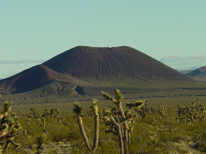
A cinder cone is a small volcano, between 100 and 400 meters tall, made up of exploded rock blasted out of a central vent at a high velocity (Figure 10n-4). These volcanoes develop from magma of basaltic to intermediate composition (andesite). They form when large amounts of gas accumulate within rising magma. Examples of cider cones include Little Lake Volcano in California and Paricutin Volcano in Mexico.
Figure 10n-4: Cinder cone volcano in the Mojave National Preserve, California. (Source: U.S. Geological Survey)
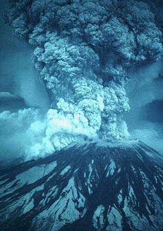
Composite volcanoes are made from alternate layers of lava flows and exploded rock. Their height ranges from 100 to 3500 meters tall. The chemistry of the magma of these volcanoes is quite variable ranging from basalt to granite. Magmas that are more granitic tend to be very explosive because of their relatively higher water content. Water at high temperatures and pressures is extremely volatile. Examples of composite volcanoes include Italy's Vesuvius, Japan's Mount Fuji, and Washington State's Mount Rainier and Mount St. Helens (see Figures 10n-5 and 10n-6).
Figure 10n-5: Mount St. Helens eruption on May 18, 1980. (Source: U.S. Geological Survey, photograph by Austin Post).
The most explosive type of volcano is the caldera. The cataclysmic explosion of these volcanoes leaves a huge circular depression at the Earth's surface. This depression is usually less than 40 kilometers in diameter. These volcanoes form when "wet" granitic magma quickly rises to the surface of the Earth. When it gets to within a few kilometers of the surface the top of the magma cools to form a dome. Beneath this dome the gaseous water in the magma creates extreme pressures because of expansion. When the pressure becomes too great the dome and magma are sent into the Earth's atmosphere in a tremendous explosion. On the island of Krakatau, a caldera type volcano exploded in 1883 ejecting 75 cubic kilometers of material in the air and left a depression in the ground some 7 kilometers in diameter.
A potentially very destructive caldera covering an area of about 2000 square kilometers exists under Yellowstone National Park in the United States. Investigations have discovered that over the last 2 million years this volcano has exploded on a regular interval of about 700,000 years. The last eruption occurred 630,000 years ago and the next could take place anytime.When the Yellowstone caldera last erupted, it blasted 1,000 cubic kilometers of volcanic ash and rock into the atmosphere. The ash ejected into the atmosphere created climatic havoc on a global scale. The ash would have blocked sunlight from being received at the ground surface for a few years. A reduction in the reception of solar radiation would have caused the globle climate to cool significantly. Over time this ash settled back to the Earth's surface covering more than half of North America.
Physiography of the Earth's Terrestrial Surface
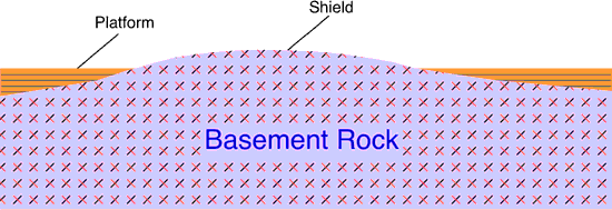
All of the continental masses on the Earth have a central foundation of very old basement rock. Basement rock is composed of mixtures of ancient granite, gneiss, schist, volcanic, plutonic, and sedimentary rocks. Some of the Earth's oldest rocks are found in this geologic formation. Basement rock that is exposed at the Earth's surface is called shield. The shields extend for thousands of kilometers and dip ever so slightly from a slightly elevated center.
Layers of younger sedimentary strata up to 2000 meters deep cover most of the basement rock. These sedimentary deposits are sometimes called the platform of the continents. The deposits making up the platform were laid down in shallow seas in repeated episodes over the last 600 million years. The platform and the basement rock together form a craton. The continents of Australia, North America, South America, and Africa each have a single continuous craton forming their nucleus. Eurasia is composed several distinct cratons that are separated from each other by the Alps, Ural, and Himalaya mountain belts.
Layers of younger sedimentary strata up to 2000 meters deep cover most of the basement rock. These sedimentary deposits are sometimes called the platform of the continents. The deposits making up the platform were laid down in shallow seas in repeated episodes over the last 600 million years. The platform and the basement rock together form a craton. The continents of Australia, North America, South America, and Africa each have a single continuous craton forming their nucleus. Eurasia is composed several distinct cratons that are separated from each other by the Alps, Ural, and Himalaya mountain belts.
Figure 10o-1: Cross section showing the relationship between basement rock and platform sedimentary deposits. Note that the surface of the basement rocks (the shield) is gently arched.
The craton of North America has been relatively stable for about 600 million years. Prior to this period, the North American continent saw several periods of very active growth with the amalgamation of once distinct cratons and the addition of rock along it's margins. Geologic evidence suggests that North America is made up of several once independent minicontinents. Scientists believe that the amalgamation of these minicontinents into the core of the North America continent was complete by about 2.5 billion years ago.
On a global scale, about 70 percent of the Earth's continental crust was formed by 2.5 billion years ago. Over the next 2 billion years, the planet's continents would continue to growth through the accretion of sedimentary rock and the addition of igneous rocks along the continental margins. This growth was also driven by tectonic processes. The accretion of sedimentary rock occurred with the collision of tectonic plates which pushed ocean sediments onto the continents. Plate subduction created enough heat to melt rock into magma beneath the margins of the continents. This magma then migrated upward through the crust to form intrusive and extrusive igneous features and deposits. This process also added significant mass to the continents.
Mountain Belts
Numerous mountain belts are also found on the continents. These features are often located on the edge of cratons. Mountain belts are the result of tectonic processes that cause to crustal plates to collide. This collision results in the folding and faulting of rock, igneous intrusive and extrusive activity, and metamorphism. The elevated relief common to mountain belts is generally caused by the compression of rock into a smaller area. Uplift may also be caused by the upward migration of magma through the crust to produce granitic batholiths. Some mountains occur in isolation like Mount Rainier in the state of Washington, USA. These features are volcanic and are produced by localized extrusive igneous activity.
Continental Margin
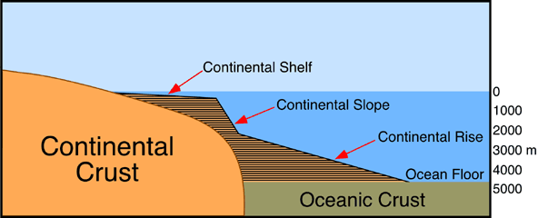
Located between the terrestrial continents and the ocean basins is the continental margin. Two basic types of continental margin are recognized: active and passive. Active continental margins occur in the Pacific ocean. Active margins are generally narrow tectonically active areas. They are also associated with earthquakes, oceanic trenches, and volcanoes. Passive continental margins are relatively wide and have a lack of volcanic activity and few earthquakes. The continental margin is actually made up of three structures: the continental shelf, the continental slope and the continental rise. Both the continental shelf and slope are structurally part of the continents, even though they are below the sea surface.
The continental shelf is a shallow (average depth 130 meters) gently sloping part of the continental crust that borders the continents (Figure 10o-2). The extent of this feature varies from tens of meters to a maximum width of about 1300 kilometers.
| Figure 10o-2: Marginal features found at the interface of the continents and the ocean basins. |
The continental slope extends from the continental shelf at an average depth of about 135 meters. The base of this steeply sloping (from 1 to 25°, average about 4°) topographic feature occurs at a depth of approximately 2000 meters, marking the edge of the continents. The width of the slope varies from 20 to 100 kilometers. The boundary between the continental slope and shelf is called the continental shelf break.
At the base of the continental slope an accumulation of sediments may develop. This accumulation of sediments is properly known as the continental rise.
The continental rise is composed of a number abyssal fans that run side-by-side along the edge of the continental slope. Abyssal fans are usually associated with a deep submarine canyon cut into the continental slope. Under water abyssal fans can be compared to terrestrial landforms known as alluvial fans. The sediments that make up this feature are transported down the continental slope by turbidity currents, underwater landslides, and several different processes that move clay, silt, and sand. Most of this sediment is terrestrial in origin. The depth of the continental rise ranges from 2000 to 5000 meters deep. The continental rise can be as much as 300 kilometers wide.
The continental rise is composed of a number abyssal fans that run side-by-side along the edge of the continental slope. Abyssal fans are usually associated with a deep submarine canyon cut into the continental slope. Under water abyssal fans can be compared to terrestrial landforms known as alluvial fans. The sediments that make up this feature are transported down the continental slope by turbidity currents, underwater landslides, and several different processes that move clay, silt, and sand. Most of this sediment is terrestrial in origin. The depth of the continental rise ranges from 2000 to 5000 meters deep. The continental rise can be as much as 300 kilometers wide.
Topography of the Terrestrial Surface
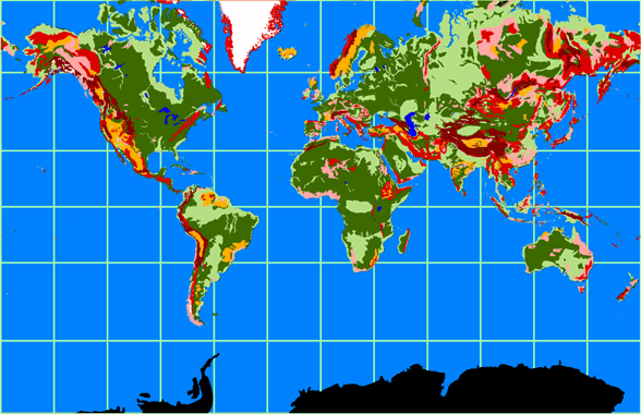
Figure 10o-3 classifies the Earth's terrestrial surface in to six different categories based on topography. Most of the Earth's terrestrial surface is dominated by reltively flat low and high plains. The low plains tend to be areas of sediment deposition because of their low elevation. The high plains can have elevations as high as 600 meters and are more strongly influenced by erosion. Both of these topographic features are often associated with craton's and their exposed shield and platform surfaces.
Local relief on both types of plains is less than 100 meters. The three types of mountains shown in Figure 10o-3 have local relief in excess of 500 meters and slope angles greater than 5°. Many of the "low" mountains are very old structures that have been reduced in height by erosion. Plateaus have altitudes that are greater than the high plains but less than mountains. Local relief of this topographic feature varies between 100 and 500 meters. Some plateaus are the remnants of eroded mountains. Others have formed because of large-scale block faulting.
Local relief on both types of plains is less than 100 meters. The three types of mountains shown in Figure 10o-3 have local relief in excess of 500 meters and slope angles greater than 5°. Many of the "low" mountains are very old structures that have been reduced in height by erosion. Plateaus have altitudes that are greater than the high plains but less than mountains. Local relief of this topographic feature varies between 100 and 500 meters. Some plateaus are the remnants of eroded mountains. Others have formed because of large-scale block faulting.
Figure 10o-3: The Earth's various topographic regions. The legend below describes the colors associated with the six topographic regions shown. Glaciers are colored white.
Physiography of the Ocean Basins
The ocean basins are the result of tectonic forces and processes. All of the ocean basins were formed from volcanic rock that was released from fissures located at the mid-oceanic ridges. The oldest rocks found in these basins are approximately 200 million years old. This is a lot younger than the oldest continental rocks which have ages greater than 4 billion years. The reason for this discrepancy is simple. Tectonic processes destroy old oceanic rocks! Oceanic rock is returned to the Earth's mantle when oceanic crust is subducted. Many of these subduction zones occur at the continental margins where oceanic crust meets continental crust. Subduction also creates the ocean's deep trenches.
Topography of the Ocean Basins
The ocean basins are not featureless Earth surfaces (Figure 10p-1). Much of our knowledge about the topographic features that exist here are derived from the following technologies: seismic surveying; echo sounder; side-scan sonar; and the measurement of the height of sea surfaces by satellites. Most of the general information concerning the depth of the ocean basins were made after World War I when the echo sounder was developed for military purposes. This instrument accurately determines the time between the emission of a strong acoustic pulse and the detection of its echo. Using this principle scientists can determine the distance from the sounder to the ocean bottom.
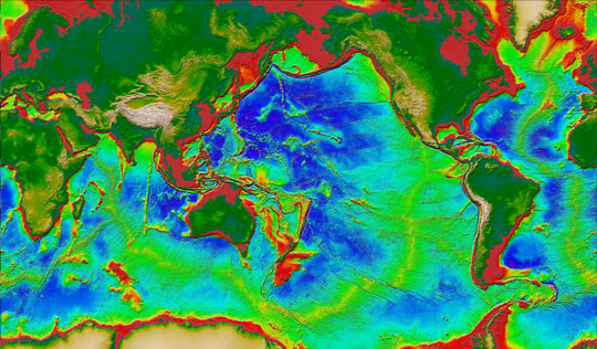 |
Figure 10p-1: The following image displays the topography of the Earth's terrestrial land surface and ocean basins. Data for the image comes from satellite altimetry and ship depth soundings, and U.S. Geological Survey digital elevation maps (DEM) of the Earth's land surface. In the ocean basin, the gradation from red to yellow to green to blue indicates increasing depth. A number of topographic features associated with the ocean basin can be seen in this image. The red area that borders the various landmasses is the continental shelf. This feature is structurally part of the continental landmasses despite the fact that it is under water. The yellow to green zone around the continental shelf is the continental slope and continental rise. The blue region in the various ocean basins constitutes the ocean floor. In the center of ocean basins, the mid-oceanic ridges can be seen with a color ranging from green to yellow to orange. (Modified from image available at the Seafloor Topography Website, Institute of Geophysics and Planetary Physics, University of California at San Diego).
Some of the dominant topographic features associated with the ocean basins include:
Continental shelf is a shallow (average depth 130 meters) gently sloping part of the continental crust that borders the continents (seeFigure 10p-1 and Figure 10p-2). The extent of this feature varies from tens of meters to a maximum width of about 1300 kilometers.
|
| Figure 10p-2: Marginal features found at the interface of the continents and the ocean basins. |
The continental slope extends from the continental shelf at an average depth of about 135 meters (see Figure 10p-2). The base of this steeply sloping (from 1 to 25°, average about 4°) topographic feature occurs at a depth of approximately 2000 meters, marking the edge of the continents. The width of the slope varies from 20 to 100 kilometers. Both the continental shelf and slope are considered structurally part of the continents, even though they are below the sea surface. The boundary between the continental slope and shelf is called the continental shelf break.
Submarine canyons are V-shaped canyons cut into the continental slope to a depth of up to 1200 meters. The submarine canyons are cut perpendicular to the running direction of the continental slope. Many canyons are associated with major rivers such as the Congo, Hudson, and others.
The continental rise is found at the base of the continental slope (see Figure 10p-1 and Figure 10p-2). The depth of the rise ranges from 2000 to 5000 meters deep. Its breadth is up 300 kilometers wide. This feature was created by the merging of accumulated deposits at the mouths of the many submarine canyons. Each canyon's thick fan-shaped sedimentary deposit is called an abyssal fans.
The ocean floor is found at the base of the continental rise in water 4000 to 6000 meters deep (see Figure 10p-1). The ocean floor accounts for nearly 30% of the Earth's surface. The composition of the ocean floor consists of a relatively thin layer (on average 5 kilometers thick) of basaltic rock with an average density of 3.0 grams per cubic centimeter (continents - granite rocks - density 2.7 grams per cubic centimeter).
Numerous volcanoes populate the floor of the ocean basins. Scientists estimate that there are approximately 10,000 volcanoes on the ocean floor.
Mid-oceanic ridge is normally found rising above the ocean floor at the center of the ocean basins (see Figure 10p-1). These features are involved in the generation of new oceanic crust from volcanic fissures produced by mantle up-welling. Some volcanic islands are part of the mid-ocean ridge system (Iceland). The mid-oceanic ridge constitutes 23% of the Earth's surface. In the center of the mid-oceanic ridge is a rift valley, between 30 to 50 kilometers wide, that dissects 1000 to 3000 meters deep into the ridge system.
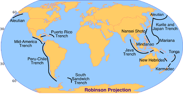
Ocean trenches are long, narrow, steep-sided depressions found on the ocean floor that contain the greatest depths in the ocean (11,000 meters - western Pacific). There are 26 oceanic trenches in the world: 3 in the Atlantic Ocean, 1 in the Indian Ocean, and 22 in the Pacific Ocean (Figure 10p-3). Generally, the trenches mark the transition between continents and ocean basins, especially in the Pacific basin. Trenches are also the tectonic areas.
Figure 10p-3: Major ocean trenches of the world. The Mariana Trench is the deepest at 11,020 meters below sea-level.
Ocean Basin Configuration |
The current spatial configuration of the ocean basins is a by product of plate tectonics. The creation of new oceanic crust at the mid-oceanic ridge moves the continents across the Earth's surface and creates zones of subduction. At the areas of subduction, oceanic crust is forced into the mantle after it collides with continental crust. Over the past 200 million years, the Atlantic basin has been the most active area of oceanic crust creation. The Atlantic ocean formed about 200 million years ago as the Pangaean continent began rifting apart. 180 million years ago, North American separated from South America and Africa. North America then joined with Eurasia creating Laurasia. By 135 million years ago, South America began separating from Africa. North America and Eurasia split a few million years after.
Models of Landform Development
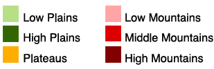
The landforms that are found on the surface of the Earth can be grouped into 4 categories:
(1) Structural Landforms - landforms that are created by the solidification of large quantities of magma or by massive movements due or rock because of plate tectonics. This includes landforms like: shield, fold mountains, rift valleys, and volcanoes.
(2) Weathering Landforms - landforms that are created by the physical, chemical or biological decomposition of rock through weathering. Weathering produces landforms where rocks and sediments are decomposed and disintegrated. This includes landforms with some of the following geomorphic features: karst, patterned ground, and soil profiles.
(3) Erosional Landforms - landforms formed from the removal of weathered and eroded surface materials by wind, water, glaciers, and gravity. This includes landforms with some of the following geomorphic features: river valleys, glacial valleys, and coastal cliffs.
(4) Depositional Landforms - landforms formed from the deposition of weathered and eroded surface materials. On occasion, these deposits can be compressed, altered by pressure, heat and chemical processes to become sedimentary rocks. This includes landforms with some of the following geomorphic features: beaches, deltas, flood plains, and glacial moraines.
Many landforms show the influence of several of the above processes. We call these landforms polygenetic. Processes acting on landforms can also change over time, and a single landscape can undergo several cycles of development. We call this type landscape development polycyclic.
The following graphical model describes the relationship between general landform types and the geomorphic processes of weathering, erosion, and sediment deposition (Figure 10q-1).
Figure 10q-1: Simple model of landform development.
(d) WEATHERING
Weathering is the breakdown and alteration of rocks and minerals at or near the Earth's surface into products that are more in equilibrium with the conditions found in this environment. Most rocks and minerals are formed deep within the Earth's crust where temperatures and pressures differ greatly from the surface. Because the physical and chemical nature of materials formed in the Earth's interior are characteristically in disequilibrium with conditions occurring on the surface. Because of this disequilbrium, these materials are easily attacked, decomposed, and eroded by various chemical and physical surface processes.
Weathering is the first step for a number of other geomorphic and biogeochemical processes. The products of weathering are a major source of sediments for erosion and deposition. Many types of sedimentary rocks are composed of particles that have been weathered, eroded, transported, and terminally deposited in basins. Weathering also contributes to the formation of soil by providing mineral particles like sand, silt, and clay. Elements and compounds extracted from the rocks and minerals by weathering processes supply nutrients for plant uptake. The fact that the oceans are saline in the result of the release of ion salts from rock and minerals on the continents. Leaching and runoff transport these ions from land to the ocean basins where they accumulate in seawater. In conclusion, weathering is a process that is fundamental to many other aspects of the hydrosphere, lithosphere, and biosphere.
There are three broad categories of mechanisms for weathering: chemical, physical and biological.
Products of Weathering
The process of weathering can result in the following three outcomes on rocks and minerals:
(1). The complete loss of particular atoms or compounds from the weathered surface.
(2). The addition of specific atoms or compounds to the weathered surface.
(3). A breakdown of one mass into two or more masses, with no chemical change in the mineral or rock.
The residue of weathering consists of chemically altered and unaltered materials. The most common unaltered residue is quartz. Many of the chemically altered products of weathering become very simple small compounds or nutrient ions. These residues can then be dissolved or transported by water, released to the atmosphere as a gas, or taken up by plants for nutrition. Some of the products of weathering, less resistant alumino-silicate minerals, become clay particles. Other altered materials are reconstituted by sedimentary or metamorphic processes to become new rocks and minerals.
Chemical Weathering
Chemical weathering involves the alteration of the chemical and mineralogical composition of the weathered material. A number of different processes can result in chemical weathering. The most common chemical weathering processes are hydrolysis, oxidation, reduction, hydration,carbonation, and solution.
Hydrolysis is the weathering reaction that occurs when the two surfaces of water and compound meet. It involves the reaction between mineral ions and the ions of water (OH- and H+), and results in the decomposition of the rock surface by forming new compounds, and by increasing the pH of the solution involved through the release of the hydroxide ions. Hydrolysis is especially effective in the weathering of common silicate and alumino-silicate minerals because of their electrically charged crystal surfaces.
Oxidation is the reaction that occurs between compounds and oxygen. The net result of this reaction is the removal of one or more electrons from a compound, which causes the structure to be less rigid and increasingly unstable. The most common oxides are those of iron and aluminum, and their respective red and yellow staining of soils is quite common in tropical regions which have high temperatures and precipitation. Reduction is simply the reverse of oxidation, and is thus caused by the addition of one or more electrons producing a more stable compound.
Hydration involves the rigid attachment of H+ and OH- ions to a reacted compound. In many situations the H and OH ions become a structural part of the crystal lattice of the mineral. Hydration also allows for the acceleration of other decompositional reactions by expanding the crystal lattice offering more surface area for reaction.
Carbonation is the reaction of carbonate and bicarbonate ions with minerals. The formation of carbonates usually takes place as a result of other chemical processes. Carbonation is especially active when the reaction environment is abundant with carbon dioxide. The formation of carbonic acid, a product of carbon dioxide and water, is important in the solution of carbonates and the decomposition of mineral surfaces because of its acidic nature.
Water and the ions it carries as it moves through and around rocks and minerals can further the weathering process. Geomorphologists call this phenomena solution. The effects of dissolved carbon dioxide and hydrogen ions in water have already been mentioned, but solution also entails the effects of a number of other dissolved compounds on a mineral or rock surface. Molecules can mix in solution to form a great variety of basic and acidic decompositional compounds. The extent, however, of rock being subjected to solution is determined primarily by climatic conditions. Solution tends to be most effective in areas that have humid and hot climates.
The most important factor affecting all of the above mentioned chemical weathering processes is climate. Climatic conditions control the rate of weathering that takes place by regulating the catalysts of moisture and temperature. Experimentation has discovered that tropical weathering rates, where temperature and moisture are at their maximum, are three and a half times higher than rates in temperate environments.
Physical Weathering
Physical weathering is the breakdown of mineral or rock material by entirely mechanical methods brought about by a variety of causes. Some of the forces originate within the rock or mineral, while others are applied externally. Both of these stresses lead to strain and the rupture of the rock. The processes that may cause mechanical rupture are abrasion, crystallization, thermal insolation, wetting and drying, and pressure release.
Abrasion occurs when some force causes two rock surfaces to come together causing mechanical wearing or grinding of their surfaces. Collision between rock surfaces normally occurs through the erosional transport of material by wind, water, or ice.
Crystallization can cause the necessary stresses needed for the mechanical rupturing of rocks and minerals. Crystal growth causes stress as a result of a compound's or an element's change of physical state with change in temperature. The transformation from liquid to solid crystalline form produces a volumetric change which in turn causes the necessary mechanical action for rupture. There are primarily two types of crystal growth that occur; they are ice and salt. Upon freezing the volumetric change of water from liquid to solid is 9%. This relatively large volumetric change upon freezing has potentially a great rupturing effect. Several researchers have discovered in the laboratory and the field that frost action plays a major role in weathering in temperate and polar regions of the Earth. The threshold temperature for frost action is at least - 5° Celsius, and it is at this temperature that the most effective rupturing occurs.
The crystallization of salt exhibits volumetric changes from 1 to 5 percent depending on the temperature of the rock or mineral surface. Most salt weathering occurs in hot arid regions, but it may also occur in cold climates. For example, cavernous salt weathering of granite is widespread in the dry valley regions of South Victoria Land, Antarctica. At this location outcrops and large boulders are pitted by holes up to 2 meters in diameter. Researchers have also found that frost weathering is greatly enhanced by the presence of salt.
The physical breakdown of rock by their expansion and contraction due to diurnal temperature changes is one of the most keenly debated topics in rock weathering research. Known as insolation weathering, it is the result of the physical inability of rocks to conduct heat well. This inability to conduct heat results in differential rates of expansion and contraction. Thus, the surface of the rock expands more than its interior, and this stress will eventually cause the rock to rupture. Differential expansion and contraction may also be due to the variance in the colors of mineral grains in rock. Dark colored grains, because of their absorptive properties, will expand much more than light colored grains. Therefore, in a rock peppered with many different colored grains, rupturing can occur at different rates at the various mineral boundaries.
Alternate wetting and drying of rocks, sometimes known as slaking, can be a very important factor in weathering. Slaking occurs by the mechanism of "ordered water", which is the accumulation of successive layers of water molecules in between the mineral grains of a rock. The increasing thickness of the water pulls the rock grains apart with great tensional stress. Recent research has shown that slaking in combination with dissolved sodium sulfate can disintegrate samples of rock in only twenty cycles of wetting and drying.
Pressure release of rock can cause physical weathering due to unloading. The majority of igneous rocks were created deep under the Earth's surface at much higher pressures and temperatures. As erosion brings these rock formations to the surface, they become subjected to less and less pressure. This unloading of pressure causes the rocks to fracture horizontally with an increasing number of fractures as the rock approaches the Earth's surface. Spalling, the vertical development of fractures, occurs because of the bending stresses of unloaded sheets across a three dimensional plane.
Biological Weathering
Biological weathering involves the disintegration of rock and mineral due to the chemical and/or physical agents of an organism. The types of organisms that can cause weathering range from bacteria to plants to animals.
Biological weathering involves processes that can be either chemical or physical in character. Some of the more important processes are:
1. Simple breaking of particles, by the consumption of soils particles by animals. Particles can also fracture because of animal burrowing or by the pressure put forth by growing roots.
2. Movement and mixing of materials. Many large soil organisms cause the movement of soil particles. This movement can introduce the materials to different weathering processes found at distinct locations in the soil profile.
3. Simple chemical processes like solution can be enhanced by the carbon dioxide produced by respiration. Carbon dioxide mixing with water forms carbonic acid.
4. The complex chemical effects that occur as a result of chelation. Chelation is a biological process where organisms produce organic substances, known as chelates, that have the ability to decompose minerals and rocks by the removal of metallic cations.
5. Organisms can influence the moisture regime in soils and therefore enhance weathering. Shade from aerial leaves and stems, the presence of roots masses, and humus all act to increase the availability of water in the soil profile. Water is a necessary component in several physical and chemical weathering processes.
6. Organisms can influence the pH of the soil solution. Respiration from plant roots releases carbon dioxide. If the carbon dioxide mixes with water carbonic acid is formed which lowers soil pH. Cation exchange reactions by which plants absorb nutrients from the soil can also cause pH changes. The absorption processes often involves the exchange of basic cations for hydrogen ions. Generally, the higher the concentration of hydrogen ions the more acidic a soil becomes.
CITATION
Pidwirny, M. (2006). Fundamentals of Physical Geography, 2nd Edition. 29/12/2011. http://www.physicalgeography.net/fundamentals/3h.html