
Soil Classification Systems have been developed to provide scientists and resource managers with generalized information about the nature of a soil found in a particular location. In general, environments that share comparable soil forming factors produce similar types of soils. This phenomenon makes classification possible. Numerous classification systems are in use worldwide. We will examine the systems commonly used in the United States and Canada.
United States Soil Classification System
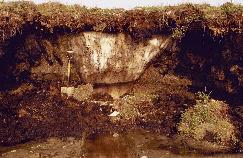
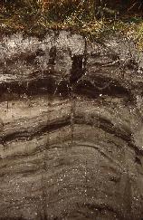
(3) Cryosol - is a high latitudes soil common in the tundra. This soil has a layer of permafrost within one meter of the soil surface. The image on the left is of tundra landscape dominated by moss and lichen vegetation. The soil profile has a permanently frozen ice wedge beneath its surface.
Figure 10v-4: Associated surface environment and profile of a gleysol soil. (Images from Soil Landscapes of Canada, Version 2.2, Agriculture and Agri-Food Canada. 1996. )
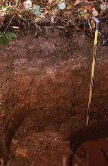
(7) Podzol - is a soil commonly found under coniferous forests. Its main identifying traits are a poorly decomposed organic layer, an eluviated A horizon, and a B horizon with illuviated organic matter, aluminum, and iron. The forested regions of southern Ontario and the temperate rainforests of British Columbia normally have podzolic soils.
The first formal system of soil classification was introduced in the United States by Curtis F. Marbut in the 1930s. This system, however, had some serious limitations, and by the early 1950s the United States Soil Conservation Service began the development of a new method of soil classification. The process of development of the new system took nearly a decade to complete. By 1960, the review process was completed and the Seventh Approximation Soil Classification System was introduced.
Since 1960, this soil classification system has undergone numerous minor modifications and is now under the control of Natural Resources Conservation Service (NRCS), which is a branch of the Department of Agriculture. The current version of the system has six levels of classification in its hierarchical structure. The major divisions in this classification system, from general to specific, are: orders, suborders, great groups, subgroups, families, and series. At its lowest level of organization, the U.S. system of soil classification recognizes approximately 15,000 different soil series.
The most general category of the NRCS Soil Classification System recognizes eleven distinct soil orders: oxisols, aridsols, mollisols, alfisols, ultisols, spodsols, entisols, inceptisols, vertisols, histosols, and andisols.
Oxisols develop in tropical and subtropical latitudes that experience an environment with high precipitation and temperature. The profiles of oxisols contain mixtures of quartz, kaolin clay, iron and aluminum oxides, and organic matter. For the most part they have a nearly featureless soil profile without clearly marked horizons. The abundance of iron and aluminum oxides found in these soils results from strong chemical weathering and heavy leaching. Many oxisols contain laterite layers because of a seasonally fluctuating water table.
Aridsols are soils that develop in very dry environments. The main characteristic of this soil is poor and shallow soil horizon development. Aridsols also tend to be light colored because of limited humus additions from vegetation. The hot climate under which these soils develop tends to restrict vegetation growth. Because of limited rain and high temperatures soil water tends to migrate in these soils in an upward direction. This condition causes the deposition of salts carried by the water at or near the ground surface because of evaporation. This soil process is of course called salinization.
Mollisols are soils common to grassland environments. In the United States most of the natural grasslands have been converted into agricultural fields for crop growth. Mollisols have a dark colored surface horizon, tend to be base rich, and are quite fertile. The dark color of the A horizon is the result of humus enrichment from the decomposition of litterfall. Mollisols found in more arid environments often exhibit calcification.
Alfisols form under forest vegetation where the parent material has undergone significant weathering. These soils are quite widespread in their distribution and are found from southern Florida to northern Minnesota. The most distinguishing characteristics of this soil type are the illuviation of clay in the B horizon, moderate to high concentrations of base cations, and light colored surface horizons.
Ultisols are soils common to the southeastern United States. This region receives high amounts of precipitation because of summer thunderstorms and the winter dominance of the mid-latitude cyclone. Warm temperatures and the abundant availability of moisture enhances the weathering process and increases the rate of leaching in these soils. Enhanced weathering causes mineral alteration and the dominance of iron and aluminum oxides. The presence of the iron oxides causes the A horizon of these soils to be stained red. Leaching causes these soils to have low quantities of base cations.
Spodsols are soils that develop under coniferous vegetation and as a result are modified by podzolization. Parent materials of these soils tend to be rich in sand. The litter of the coniferous vegetation is low in base cations and contributes to acid accumulations in the soil. In these soils, mixtures of organic matter and aluminum, with or without iron, accumulate in the B horizon. The A horizon of these soils normally has an eluvial layer that has the color of more or less quartz sand. Most spodosols have little silicate clay and only small quantities of humus in their A horizon.
Entisols are immature soils that lack the vertical development of horizons. These soils are often associated with recently deposited sediments from wind, water, or ice erosion. Given more time, these soils will develop into another soil type.
Inceptisols are young soils that are more developed than entisols. These soils are found in arctic tundra environments, glacial deposits, and relatively recent deposits of stream alluvium. Common characteristics of recognition include immature development of eluviation in the A horizon and illuviation in the B horizon, and evidence of the beginning of weathering processes on parent material sediments.
Vertisols are heavy clay soils that show significant expansion and contraction due to the presence or absence of moisture. Vertisols are common in areas that have shale parent material and heavy precipitation. The location of these soils in the United States is primarily found in Texas where they are used to grow cotton.
Histosols are organic soils that form in areas of poor drainage. Their profile consists of thick accumulations of organic matter at various stages of decomposition.
Andisols develop from volcanic parent materials. Volcanic deposits have a unique process of weathering that causes the accumulation of allophane and oxides of iron and aluminum in developing soils.
Canadian System of Soil Classification Canada's first independent taxonomic system of soil classification was first introduced in 1955. Prior to 1955, systems of classification used in Canada were strongly based on methods being applied in the United States. However, the U.S. system was based on environmental conditions common to the United States. Canadian soil scientists required a new method of soil classification that focused on pedogenic processes in cool climatic environments.
Like the US system, the Canadian System of Soil Classification differentiates soil types on the basis of measured properties of the profile and uses a hierarchical scheme to classify soils from general to specific. The most recent version of the classification system has five categories in its hierarchical structure. From general to specific, the major categories in this system are: orders, great groups, subgroups, families, and series. At its most general level, the Canadian System recognizes nine different soil orders:
Like the US system, the Canadian System of Soil Classification differentiates soil types on the basis of measured properties of the profile and uses a hierarchical scheme to classify soils from general to specific. The most recent version of the classification system has five categories in its hierarchical structure. From general to specific, the major categories in this system are: orders, great groups, subgroups, families, and series. At its most general level, the Canadian System recognizes nine different soil orders:
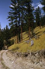
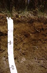
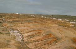
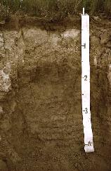
(1) Brunisol - is a normally immature soil commonly found under forested ecosystems. The most identifying trait of these soils is the presence of a B horizon that is brownish in color. The soils under the dry pine forests of south-central British Columbia are typically brunisols.
 |
 |
Brunisolic Pine Landscape
(Central British Columbia)
|
Brunisol Profile
|
Figure 10v-1: Associated surface environment and profile of a brunisol soil. (Images from Soil Landscapes of Canada, Version 2.2, Agriculture and Agri-Food Canada. 1996. )
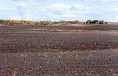
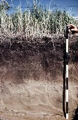
(2) Chernozem - is a soil common to grassland ecosystems. This soil is dark in color (brown to black) and has an A horizon that is rich in organic matter. Chernozems are common in the Canadian prairies. The images below are from the eastern prairies where higher seasonal rainfalls produce black chernozemic soils.
 |
 |
Chernozemic Landscape (Prairies)
|
Chernozen Profile
|
Figure 10v-2: Associated surface environment and profile of a chernozem soil. (Images from Soil Landscapes of Canada, Version 2.2, Agriculture and Agri-Food Canada. 1996. )
(3) Cryosol - is a high latitudes soil common in the tundra. This soil has a layer of permafrost within one meter of the soil surface. The image on the left is of tundra landscape dominated by moss and lichen vegetation. The soil profile has a permanently frozen ice wedge beneath its surface.
 |
 |
Tundra Cryosolic Landscape
(N.W.T.)
|
Organic Cryosol Profile
|
Figure 10v-3: Associated surface environment and profile of a cryosol soil. (Images from Soil Landscapes of Canada, Version 2.2, Agriculture and Agri-Food Canada. 1996. )
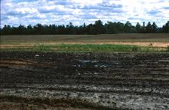
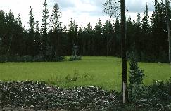
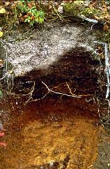
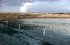
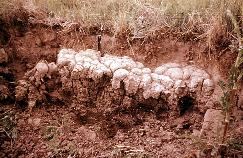
(4) Gleysol - is a soil found in an ecosystem that is frequently flooded or permanently waterlogged. Its soil horizons show the chemical signs of oxidation and reduction.
 |
 |
Flooded Gleysolic Landscape
(Atlantic Coast)
|
Gleysol Profile
|
Figure 10v-4: Associated surface environment and profile of a gleysol soil. (Images from Soil Landscapes of Canada, Version 2.2, Agriculture and Agri-Food Canada. 1996. )
(5) Luvisol - is another type of soil that develops under forested conditions. This soil, however, has a calcareous parent material which results in a high pH and strong eluviation of clay from the A horizon.
 |
 |
Luvisolic Sub-Boreal Forest
Landscape (Northern British Columbia)
|
Luvisol Profile
|
Figure 10v-5: Associated surface environment and profile of a luvisol soil. (Images from Soil Landscapes of Canada, Version 2.2, Agriculture and Agri-Food Canada. 1996. )
(6) Organic - this soil is mainly composed of organic matter in various stages of decomposition. Organic soils are common in fens and bogs. The profiles of these soils have an obvious absence of mineral soil particles.
 |
 |
Organic Soil Landscape (British
Columbia)
|
Organic Soil Profile
|
Figure 10v-6: Associated surface environment and profile of an organic soil. (Images from Soil Landscapes of Canada, Version 2.2, Agriculture and Agri-Food Canada. 1996. )
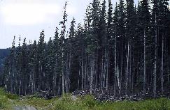
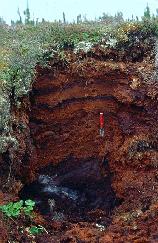
(7) Podzol - is a soil commonly found under coniferous forests. Its main identifying traits are a poorly decomposed organic layer, an eluviated A horizon, and a B horizon with illuviated organic matter, aluminum, and iron. The forested regions of southern Ontario and the temperate rainforests of British Columbia normally have podzolic soils.
 |
 |
Forested Podzolic Landscape
(Ontario)
|
Podzol Profile
|
Figure 10v-7: Associated surface environment and profile of a podzol soil. (Images from Soil Landscapes of Canada, Version 2.2, Agriculture and Agri-Food Canada. 1996. )
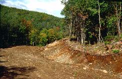
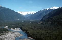
(8) Regosol - is any young underdeveloped soil. Immature soils are common in geomorphically dynamic environments. Many mountain river valleys in British Columbia have floodplains with surface deposits that are less than 3000 years old. The soils in these environments tend to be regosols.
 |
 |
Immature Regosolic Landscape
(Floodplain British Columbia)
|
Regosol Profile
|
Figure 10v-8: Associated surface environment and profile of a regosol soil. (Images from Soil Landscapes of Canada, Version 2.2, Agriculture and Agri-Food Canada. 1996. )
(9) Solonetzic - is a grassland soil where high levels of evapotranspiration cause the deposition of salts at or near the soil surface. Solonetzic soils are common in the dry regions of the prairies where evapotranspiration greatly exceeds precipitation input. The movement of water to the earth's surface because of capillary action, transpiration, and evaporation causes the deposition of salts when the water evaporates into the atmosphere.
 |
 |
Saline
Solonetzic Landscape (Saskatchewan)
|
Solonetzic
Profile
|
Figure 10v-9: Associated surface environment and profile of a solonetzic soil. (Images from Soil Landscapes of Canada, Version 2.2, Agriculture and Agri-Food Canada. 1996. )
CITATION
Pidwirny, M. (2006). "Soil Classification". Fundamentals of Physical Geography, 9/1/2012. Date Viewed. http://www.physicalgeography.net/fundamentals/10v.html