
El Niño is the name given to the occasional development of warm ocean surface waters along the coast of Ecuador and Peru. When this warming occurs the usual upwelling of cold, nutrient rich deep ocean water is significantly reduced. El Niño normally occurs around Christmas and usually lasts for a few weeks to a few months. Sometimes an extremely warm event can develop that lasts for much longer time periods. In the 1990s, strong El Niños developed in 1991 and lasted until 1995, and from fall 1997 to spring 1998.
The formation of an El Niño is linked with the cycling of a Pacific Ocean circulation pattern known as the southern oscillation. In a normal year, a surface low pressure develops in the region of northern Australia and Indonesia and a high pressure system over the coast of Peru (see Figure 7z-1 below). As a result, the trade winds over the Pacific Ocean move strongly from east to west. The easterly flow of the trade winds carries warm surface waters westward, bringing convective storms to Indonesia and coastal Australia. Along the coast of Peru, cold bottom water wells up to the surface to replace the warm water that is pulled to the west.
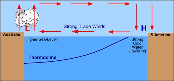
Figure 7z-1: This cross-section of the Pacific Ocean, along the equator, illustrates the pattern of atmospheric circulation typically found at the equatorial Pacific. Note the position of the thermocline.
In an El Niño year, air pressure drops over large areas of the central Pacific and along the coast of South America (see Figure 7z-2 below). The normal low pressure system is replaced by a weak high in the western Pacific (the southern oscillation). This change in pressure pattern causes the trade winds to be reduced. This reduction allows the equatorial counter current (which flows west to east) to accumulate warm ocean water along the coastlines of Peru and Ecuador (Figure 7z-3). This accumulation of warm water causes the thermocline to drop in the eastern part of Pacific Ocean which cuts off the upwelling of cold deep ocean water along the coast of Peru. Climatically, the development of an El Niño brings drought to the western Pacific, rains to the equatorial coast of South America, and convective storms and hurricanes to the central Pacific.
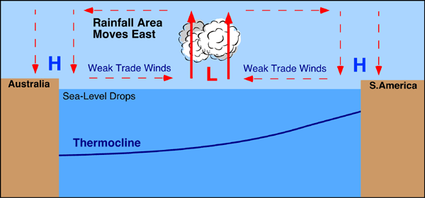
Figure 7z-2: This cross-section of the Pacific Ocean, along the equator, illustrates the pattern of atmospheric circulation that causes the formation of the El Niño. Note how position of the thermocline has changed from Figure 7z-1.
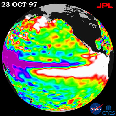
Figure 7z-3: NASA's TOPEX/Poseidon satellite is being used to monitor the presence of El Niño. Sensors on the satellite measure the height of the Pacific Ocean. The scale below describes the relationship between image color and the relative surface height of the ocean. In the image above, we can see the presence of a strong El Niño event in the eastern Pacific (October, 1997). The presence of the El Niño causes the height of the ocean along the equator to increase from the middle of the image to the coastline of Central and South America. (Source: NASA - TOPEX/Poseidon).
After an El Niño event weather conditions usually return back to normal. However, in some years the trade winds can become extremely strong and an abnormal accumulation of cold water can occur in the central and eastern Pacific (Figure 7z-4). This event is called a La Niña. A strong La Niña occurred in 1988 and scientists believe that it may have been responsible for the summer drought over central North America. The most recent La Niña began developing in the middle of 1998 and was persistent into the winter of 2000. During this period, the Atlantic Ocean has seen very active hurricane seasons in 1998 and 1999. In 1998, ten tropical storm developed of which six become full-blown hurricanes.
One of the hurricanes that developed, named Mitch, was the strongest October hurricane ever to develop in about 100 years of record keeping. Some of the other weather effects of La Niña include abnormally heavy monsoons in India and Southeast Asia, cool and wet winter weather in southeastern Africa, wet weather in eastern Australia, cold winter in western Canada and northwestern United States, winter drought in the southern United States, warm and wet weather in northeastern United States, and an extremely wet winter in southwestern Canada and northwestern United States.
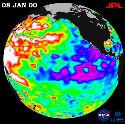
Figure 7z-4: TOPEX/Poseidon satellite image of a moderate La Niña condition (January, 2000). The scale below describes the relationship between image color and the relative surface height of the ocean. The presence of the La Niña causes the height of the ocean either side of the equator to decrease from the middle of the image to the coastline of North, Central, and South America. (Source: NASA -TOPEX/Poseidon).
Prior to the 1980s and 1990s, strong El Niño events occurred on average every 10 to 20 years. In the early 1980s, the first of a series of strong events developed. The El Niño of 1982-83 brought extreme warming to the equatorial Pacific. Surface sea temperatures in some regions of the Pacific Ocean rose 6° Celsius above normal. The warmer waters had a devastating effect on marine life existing off the coast of Peru and Ecuador. Fish catches off the coast of South America were 50% lower than the previous year.
The 1982-83 El Niño also had a pronounced influence on weather in the equatorial Pacific region and world wide. Severe droughts occurred in Australia, Indonesia, India and southern Africa. Dry conditions in Australia resulted in a 2 billion dollar loss in crops, and millions of sheep and cattle died from lack of water. Heavy rains were experienced in California, Ecuador, and the Gulf of Mexico.
Our understanding of the processes responsible for the development of El Niño is still incomplete. Scientists are able to predict the future development of an event by noting the occurrence of particular weather precursors. Researchers also now have a pretty complete understanding of the global weather effects caused by the formation of an El Niño (see Figure 7z-5).
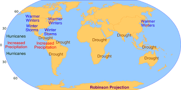
Figure 7z-5: Global climatological effects of the El Niño.
CITATION
Pidwirny, M. (2006). "El Niño, La Niña and the Southern Oscillation". Fundamentals of Physical Geography, 2nd Edition. 6/1/2012. http://www.physicalgeography.net/fundamentals/7z.htmlDo you like this post? Please link back to this article by copying one of the codes below.
URL: HTML link code: BB (forum) link code: